Day 1- Drive from Srinagar to Sonamarg
Drive: 81 km, 2-3 hrs
Trek: 0.5 km to reach the campsite
Altitude: 5,220 ft (1,590 m) – 9,022 ft (2,750 m)
Accommodation: Camping (Alpine Tents)
Meals: Dinner
We leave Srinagar around 1 PM and reach Sonamarg by 4:30 PM, following the Sind River. Once we cross over to the true right of the river at Wayil Bridge, which is 25 KM ahead of Srinagar, we encounter the Anchar lake of Srinagar on the way. The drive is a gradual climb all the way to Sonamarg, and from an altitude of 1,600 meters at Srinagar, we reach a modest altitude of slightly over 2,700 meters at Sonamarg. We will camp overnight at Shitkadi and will have to walk a short distance of 500 meters to reach our campsite.
Your trek leader will inform you in detail about the entire trek, giving you all the details that you need. The campsite is located next to a stream offering a stunning view of Thajiwas Glacier. There is no sound other than the gentle music of the river.
Day 2- Trek from Sonmarg camp to Nichinai Camp
Trek: 11 km, 5-6 hrs
Altitude: 9,022 ft (2,750 m) – 11,811 ft (3,600 m)
Accommodation: Camping (Alpine Tents)
Meals: Breakfast + Lunch + Evening Snacks + Dinner
From our camp at Shitkadi, we start the trek towards the Nichinai camp. Throughout the day, we follow the Nichinai stream, which is on our right.
After a 1.5 KM trek upstream, we arrive at a meadow with maple trees dotting the landscape, along with pines. The trail continues to climb up the ridge, and as we gain more altitude, the view towards Sonamarg becomes quite picturesque.
The maples continue all the way up to the top of the ridge, lining the eastern slope of the ridge. As we reach the top of the ridge, the place is called Table Top, one of the highest points, providing spectacular views of both the Sonmarg Valley and the Amarnath Valley. From here you can engage the local people and shepherds. It is also a lunch point and you can eat Maggie and other local goodies placed by the shops around the Table Top after that an open grassland paves the way that gradually descends to some distance. To the west of the grassland, silver birch (Bhojpatra) trees stand tall, while to the east, the maples can still be seen. This meadow, known as Shekdur, runs almost 1.5 KM long. As we approach its end, the trail then enters the forest of silver birch for almost 1 KM before the treeline finally comes to an end.
Henceforth, we continue on the trail marked by patches of grassland and stone all the way to Nichinai. We are surrounded by tall mountains on either side and towards our back lie the snow-covered mountains far across the Sonamarg valley. We will reach Nichinai by early evening and set up the camps.
Day 3- Trek from Nichinai to Vishnusar (Vishansar) & Kishansar Lakes via Nichinai Pass
Trek: 13 km, 6 hrs
Altitude: 11,811 ft (3,600 m) – 13,100 ft (3,993 m)
Accommodation: Camping (Alpine Tents)
Meals: Breakfast + Lunch + Evening Snacks + Dinner
The trek from Nichinai camp starts with an ascent to the Nichinai Pass. The altitude of Nichinai Pass is around 13,100 Feet, which is quite close to the altitude of Hampta Pass or the Sar Pass, and higher than Kuari Pass. So, take pride in the fact that so early into the trek, you have already crossed over a pass. The ascent takes a good couple of hours to reach the pass from the campsite at a moderate pace.
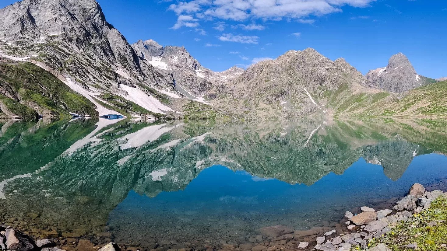
As soon as we cross over the Nichinai Pass, we can see a small lake at the base of the mountain to our left. There is another larger lake, almost 500 meters in length, around 2 KM ahead, but it cannot be seen unless we climb up to the ridge to our right.
The trail continues downhill from the pass and enters grassland with a gentle slope after an hour of descent. From here, the trail is gentle up to the Vishansar Lake. It’s a few KM before we reach the base of the lake and our campsite. The lake will require another 20 mins to reach as it is slightly higher in altitude. Kishansar is further ahead of the Vishansar lake and higher in altitude still.
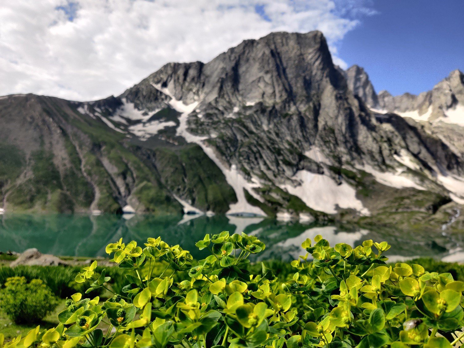
The lakes are quite large, and while the Vishansar runs 1.1 KM long and a little over 700 meters wide, the Kishansar is slightly smaller at 900 meters long and 550 meters wide. The latter’s shape is more of a triangular one with an inward arc on one side.
After reaching the campsite which is near the Vishansar Lake or below the Vishansar Lake, you can spend some time over there around the lake, this campsite is considered one of the best campsites of this KGL trek.
Day 4- Trek from Vishansar lake (Vishnusar) to Gadsar via Gadsar pass
Trek: 16 km, 7-8 hrs
Altitude: 13,100 ft (3,993 m) – 13, 813 ft (4,210 m) – 12,500 ft (3,810 m)
Accommodation: Camping (Alpine Tents)
Meals: Breakfast + Lunch + Evening Snacks + Dinner
The trek from Vishansar to Gadsar is beautiful but demanding. Today’s trek will take you across the highest point of the entire trek, at a modest altitude of 4,210 meters at the Gadsar Pass.
The trail from the Vishansar campsite continues to the right, with Kishansar lake on our left as we cross it. The trail then starts climbing with a steep ascent all the way to the pass, and the trail that cuts across the mountain in zig-zags can be seen from far away.
It will take around 2 hours to reach the Gadsar Pass. As we climb higher, we are rewarded with magnificent views of the two lakes as we turn our backs. Take some time to capture these moments in your mind, as you will cherish them for the rest of your life.
As you come down from the Gadsar Pass, you will be amazed to see the beauty of Gadasr Lake. It is considered to be one of the most beautiful lakes of this trek and you can enjoy your packed lunch here while admiring the scenery.
Day 5- Trek from Gadsar to Satsar
Trek: 12 km, 6 hrs
Altitude: 12,500 ft (3,810 m) – 12,007 ft (3,660 m)
Accommodation: Camping (Alpine Tents)
Meals: Breakfast + Lunch + Evening Snacks + Dinner
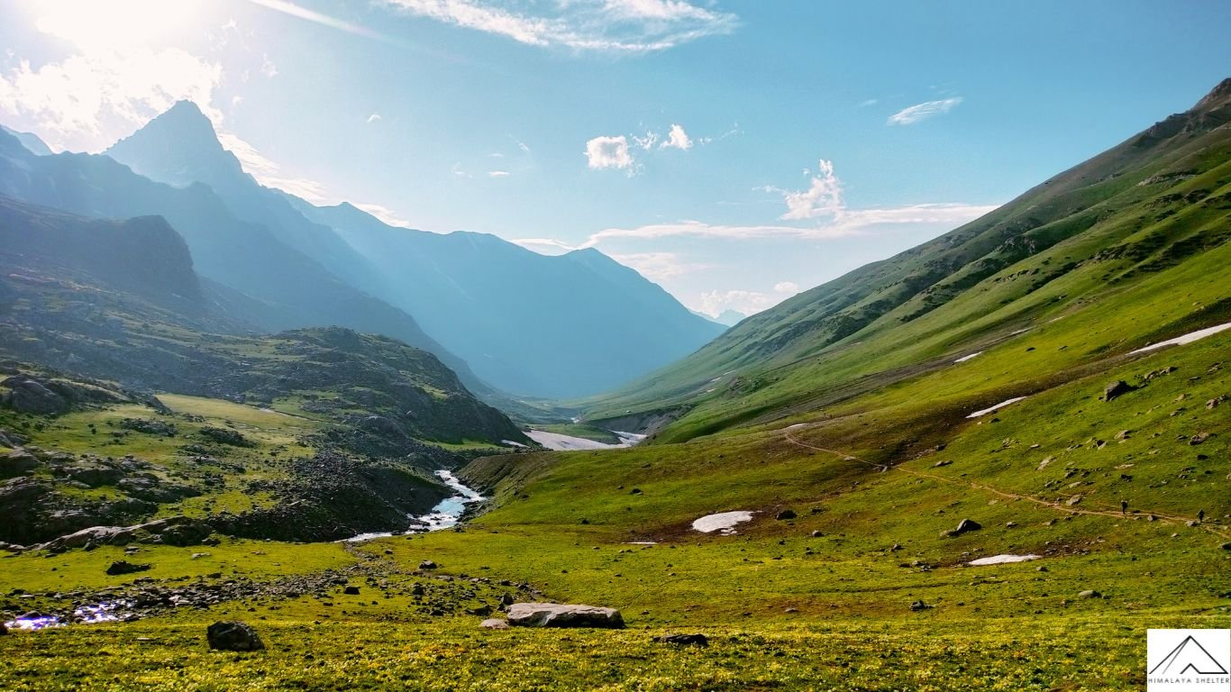
The trek from Gadsar to Satsar starts with an initial steep hike that will take a little over an hour, After that, gradually trek on the ridge. While passing that ridge, you will witness the majestic Nanga Parbat (8,126). The trail then opens to plain meadows and a water stream. You can have your packed lunch here. Afterward, gradually ascend to rocky terrain, and after some time, you will reach the Satsar campsite
This will be a relatively easier day compared to other trek days. The KGL Trek is indeed a trek with long walking distance but today, this trek will offer you a good time to rest/explore.
Day 6- Trek from Satsar to Gangabal Lake and Nund Kol Lake via Zaj Pass
Trek: 9 km, 5-6 hr
Altitude: 12,007 ft (3,660 m) – 11,482 ft (3,500 m)
Accommodation: Camping (Alpine Tents)
Meals: Breakfast + Lunch + Evening Snacks + Dinner
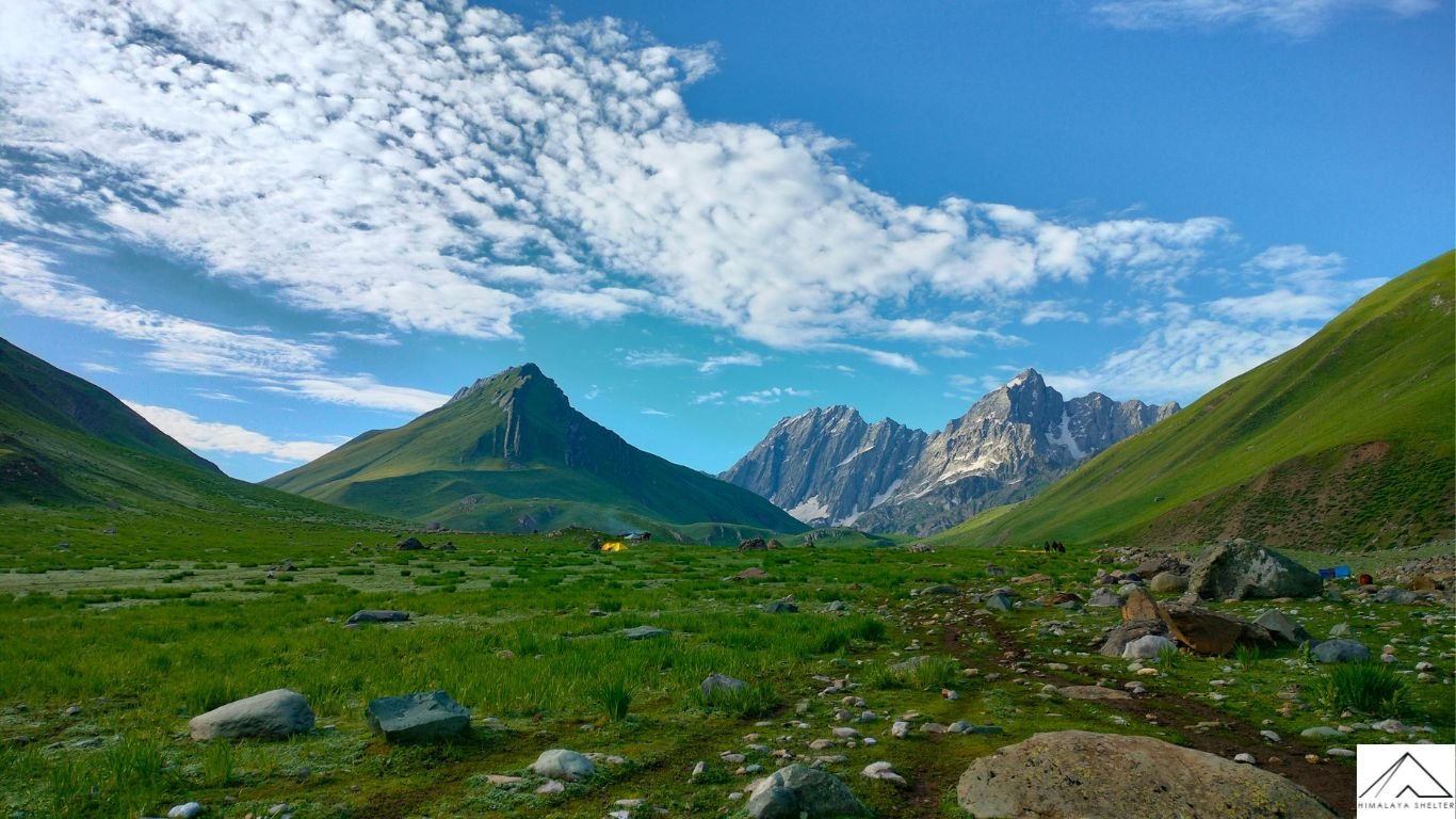
The trek starts with an ascent to the Zaj Pass, the trail to the Zaj Pass you have to cross the boulder’s path
The altitude of the Zaj Pass is lower than the former two passes we crossed before along the trail with an altitude of 13,228 feet, it takes 2 hours to reach the pass from the pass you can see Gangbal and Nandkul lakes
The view from the pass is very beautiful The trail descends steeply and then gradually descends, making it enjoyable to walk upon.
Day 7- Trek from Gangabal lake to Naranag & drive to Srinagar
Trek: 13 km, 5-6 hrs
Drive: 50 km, 2 hrs
Altitude: 11,482 ft (3,500 m) – 7,447 ft (2,270 m)
Meals: Breakfast
On the last trekking day, after half an hour of trekking, we reached the Army check post where it took half an hour to check the documents (Adhar Card) of all the trekkers.
Then, we move ahead while the trail oscillates between minor ascents and descents up to halfway, after which there is a steep descent amid pine forests all the way to Naranag. Our beautiful KGL Trek ends here.
We arrive in Srinagar between 5 and 7 PM, depending on the start time from Gangabal. We are sure that you will get so many pleasant memories to cherish by embarking on the Trek with Himalaya Shelter.
